


Al-al-Khalīfa Neighborhood
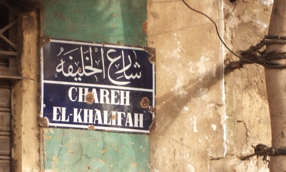
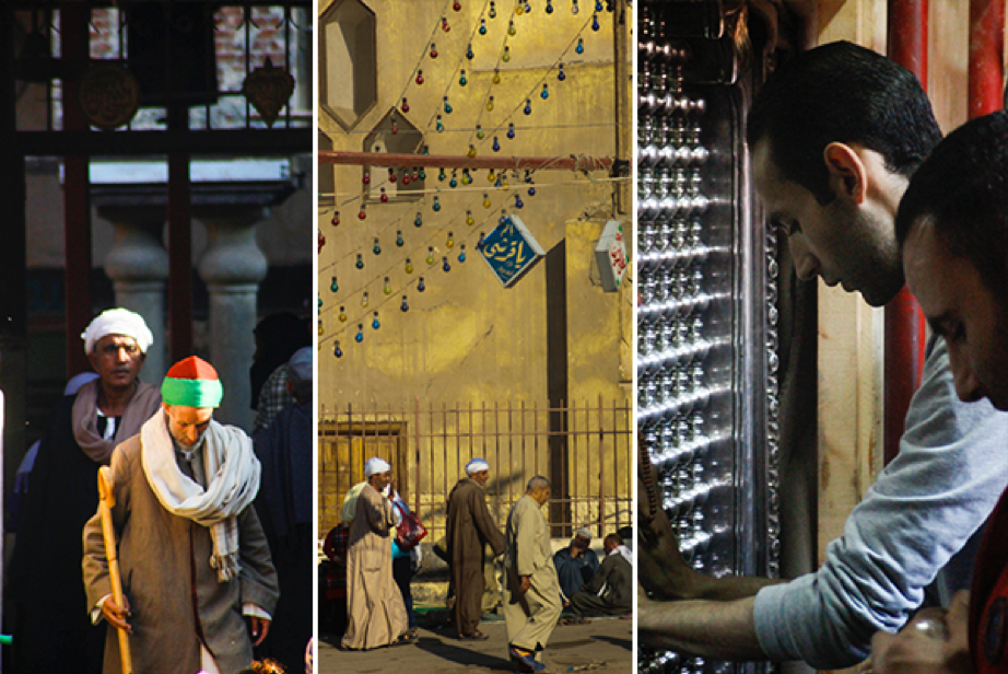
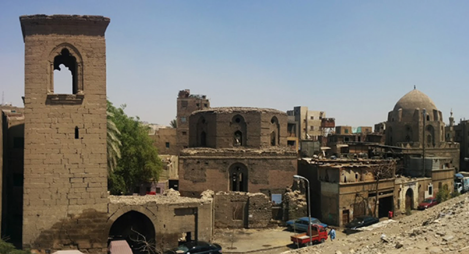
The Al-Khalīfa neighborhood begins at al-Sayyida Nafiysa Square and ends at Ṭūlūn Street. Part of the street was renamed recently to al-Ashrāf Street (the honorable descendants of the prophet), as it contains shrines to the Prophet’s descendants. The street begins at al-Sayyida Nafisa Square and meets three other streets: Ṭūlūn, al-Raqayba, and Darb al-Ḥuṣar, forming a small public square containing the al-Khalīfa market. Photo: Our Impact Initiative
Al-Khalīfa neighborhood
The geographical area occupied by al-Khalīfa has been a settled, vibrant community for more than eleven hundred years. ʿAmr Bin al-ʿāṣ, the Arab general who led the Muslim conquest of Egypt in 642 AD, at the beginning of the Islamic era, established his rule in al-Fusṭāṭ, replacing Alexandria which had served as Egypt’s capital during the Byzantine era. What is now Cairo, emerged out of three Islamic cities al-Fusṭāṭ, al-ʿAskar, and al-Qaṭa’i`. Al-Khalifa occupies the same area that was once al-Qaṭaʾiʿ, the ancient capital of the Tulunid dynasty from 868 and 905 AD. In 905, the Abbasids reoccupied Egypt and burned al-Qaṭaʾiʿ to the ground. The Fatimids conquered Egypt in 969 and founded al-Qahira “the Victorious,” (Cairo) designating it as the capital of their caliphate, centered in Tunis. Cairo continued as the governing capital from the pre-Middle Ages to the present without interruption. The collective consciousness of most Egyptians view Cairo as the eternal capital of Egypt.
The neighborhood of al-Khalīfa is located within the Historic Cairo area and has been included on UNESCO’s World Heritage List as ‘Islamic Cairo,’ due to its indisputable historical, archaeological, and architectural significance. Islamic Cairo has been recognized as a global heritage site because it contains many distinctive monuments and still preserves the human settlement that dates back to the Middle Ages at the heart of its urban fabric. Due to its status, any development efforts in the region are coupled with efforts to preserve archaeological sites and the urban fabric, promoted and required by the UNESCO World Heritage Committee. This means that the urban heritage of the neighborhood and the surrounding areas of Historic Cairo is not the exclusive property of its current residents. The area must not only meet the needs of the local population and respond to changes in their social, economic and political circumstances but its cultural prominence is shared and experienced by a global audience. This also means that there is an international body, the United Nations, charged with protecting this heritage.
The Cairo Governorate official website describes al-Khalīfa as:
[O]ne of the richest neighborhoods in Cairo with historical and religious monuments, which is a distinctive feature of the neighborhood and a national treasure that needs to be preserved and developed […] the al-Khalīfa neighborhood is characterized by traditional areas with old buildings and ancient tombs carrying significant religious and folk history and nature. Activities in all parts of the neighborhood have been marked by the neighborhood’s distinctive features […] There are many programs that serve the historical and religious areas in al-Khalīfa to preserve the cultural heritage. Various entities participate in these programs, and each of them is concerned with its area of competence (Supreme Council of Antiquities, Ministry of Culture, and Ministry of Tourism).
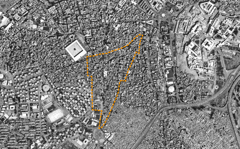
The boundaries of the al-Khalīfa area from the point of view of its inhabitants. Source: Tadamun 2016
There is no doubt that architectural heritage is an important resource for a society that preserves its memory and history. There is also no doubt that the international commitment to the preservation of “World Heritage,” at times presents challenges to the Egyptian authorities. However, we should not only be concerned with the historical buildings registered in these areas. We must take care of the lives of the communities living in these historical areas and address their problems and needs. The official website of Caro Governorate should not only emphasize the historic dimension of al-Khalīfa but also inform its residents about the roles of other governmental agencies that are concerned with health, education, and employment opportunities. These needs are not related to archeological sites, tourism, or heritage.
In this brief, we present al-Khalīfa as a part of a residential neighborhood with more than 100,000 inhabitants, and as a part of other larger neighborhoods in Historic Cairo which are inhabited by millions of people. We explore the al-Khalīfa area, its community life, and its historical development, to understand the specificity of its problems and analyze the discourse about the relationship between the lives of its inhabitants and the historical monuments around them. We seek to get a closer perspective on resident’s economic circumstances and livelihoods, to understand how they are affected by the historic area’s development projects and the development initiatives implemented collaboratively by civil society, Egyptian governmental agencies, and concerned international institutions. We explore how development projects have often failed to take residents’ needs into consideration and discuss some of the ways that residents have advocated on behalf of themselves and their neighborhood.
Al-Khalīfa in numbers
Governorate: Cairo
Neighborhood: Al-Khalīfa
Area: 0.092 km² (Zaghow 2011)
Population: 3,945 (Central Agency for Public Mobilization and Statistics 2006)
The Al-Khalīfa neighborhood begins at al-Sayyida Nafiysa Square and ends at Ṭūlūn Street. The main road is al-Khalīfa Street, which represents the al-Khalīfa shiyākha, or neighborhood, the smallest administrative division of local administration in Egypt (which belongs to a larger district, the next level of local administrative units, also named al-Khalīfa). The neighborhood of al-Khalīfa is located between the al-Sayyida Zaynab, Miṣr al-Qadīma, and al-Muqaṭṭam neighborhoods. The neighborhood contains historic residential areas and cemeteries alongside densely populated informal housing areas (ashwa’iyāt) and debilitated public housing units.
Here, we concentrate on describing the northwest side of the greater al-Khalīfa neighborhood, which forms the al-Khalīfa shiyākha. The administrative boundaries of each shiyākha do not necessarily coincide with the citizen’s perception of their area’s boundaries, which are flexible due to the overlap between adjacent areas. Hence, residents of areas around streets that are located in al-Sayyida, al-Baqlī, Darb Ghaziyya, and Darb al-Ḥuṣar assume that they are part of al-Khalīfa shiyākha. The area also overlaps with other shiyākhas in the al-Sayyida Zaynab neighborhood, such as the Ṭūlūn shiyākha and the Zaīnhum shiyākha (Tadamun 2016).
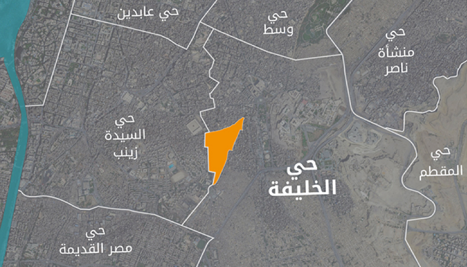
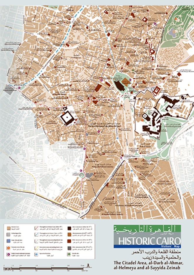
Areas surrounding al-Khalīfa neighborhood. Map of neighborhoods. Source: Tadamun 2016
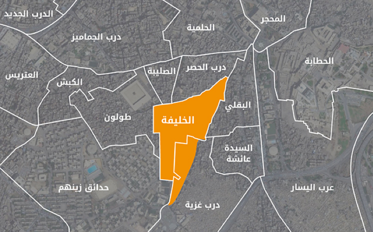
Areas surrounding al-Khalīfa shiyākha. Shiyākhas Map. Source: Tadamun 2016.
The story of al-Khalīfa
The al-Khalīfa area has never been as important as it was when it was first established. It was founded to inaugurate a new ruling dynasty; to confirm its authority and power; and to be the capital of its rule over Egypt as the third Islamic capital city of Egypt, after al-Fusṭāṭ and al-`Askar. Aḥmad ibn Ṭūlūn ascended to rule Egypt in 868 AD after a long period of political conflict. He followed the approach of his predecessors, the Abbasids, in establishing a new “ruling” city and transferring the center of power to it. He took care to plan and design it to symbolize the majesty of his rule. Aḥmad ibn Ṭūlūn was a Turk who ruled over the Mesopotamian city of Sāmarrāʾ, prior to gaining control of Egypt. Though under the domination of the Abbasid Caliphate, for the first time since the Roman occupation, Aḥmad ibn Ṭūlūn and his successors founded what resembled an independent state, and the Tulunids political power grew significantly, even invading Syria later in 878 AD (Raymond 2007).
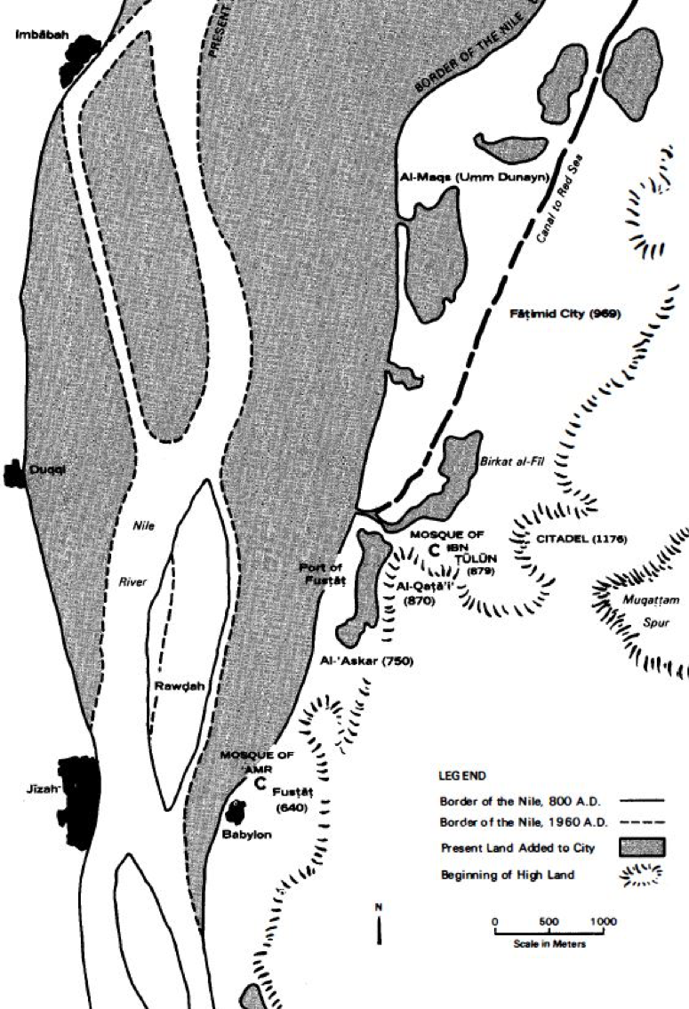
A map illustrating the locations of the founding cities that preceded the construction of Cairo: al-Fusṭāṭ, al-Qaṭaʾiʿ, and al-ʿAskar, as well as the land added to the city from the receding of the river. The solid line represents the borders of the river in 800 AD. The dashed line represents the borders of the river in 1960 AD. The map shows the location of al-Qaṭaʾiʿ (currently al-Khalīfa) and Ibn Ṭūlūn Mosque located between Mount Yashkur and Birkit al-Fīl. Source: Abu-Lughod 1971
Ibn Ṭūlūn built a mosque on the low slope of Mount Yashkur, and it is one of the oldest and most important Islamic monuments in Egypt. The mosque, constructed between 876 and 879 AD, followed the architectural style of Sāmarrāʾ mosques, characterized by their spiral minarets. This distinctive architectural feature was unknown to Egyptians before this mosque was built. Aḥmad ibn Ṭūlūn then built Dār al-ʿImāra to replace the existing government headquarters in the city of al-ʿAskar. Dār al-ʿImāra was located south of the mosque and was linked to the mosque through a passage that opened near the minbar; a raised platform in the front area of a mosque prayer hall, from which sermons or speeches are given. The palace (al-Qaṣr) of Ibn Ṭūlūn was built next to what later became the Citadel of Cairo. The back of the palace faces Mount al-Muqaṭṭam while the front overlooks a broad view of the city, the Nile, and al-Fusṭāṭ’s harbor. The square in front of the Citadel was used for processions and military parades (Raymond 2007). There was a street connecting the palace to the mosque, probably matching the path of al-Salībiyya Street in subsequent eras. Ibn Tūlūn also constructed a hospital to the west of al-`Askar in 874 AD (Raymond, 2007). Though al-Fusṭāṭ and al-ʿAskar were built close to water resources, al-Qaṭaʾiʿ was far from the Nile, which required Ibn Ṭūlūn to build a canal to facilitate the supply of water to the city and its vital facilities. Some parts of the canal between Birkit al-Ḥabash and al-Qaṣr are still standing (Raymond 2007). Al-Qaṭaʾiʿ was the best planned among the three founding cities that preceded the establishment of Cairo in the Fatimid era. However, like its predecessors, al-Qaṭa’i` was not linked to a regional economy. While al-Qaṭa’i` attracted a market for expensive commodities, al-Fusṭāṭ remained the center for most economic activities, as goods arrived in its harbor, and it hosted many crafts and artisansal production, away from the luxury and aesthetics of the Tulunids’ city (Abu-Lughod, 1971).
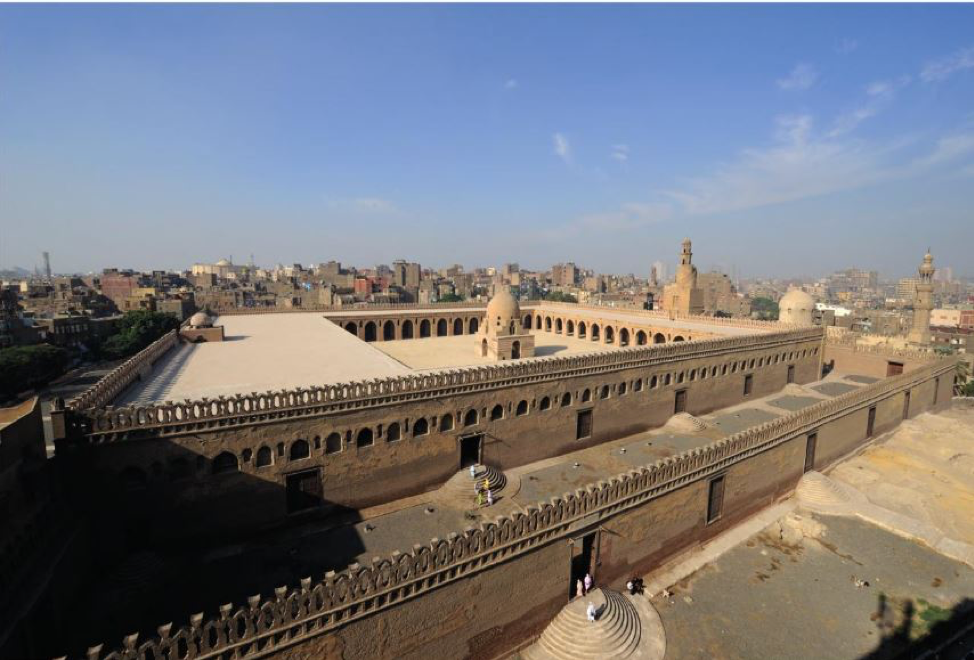
Ibn Ṭūlūn Mosque, one of the most important and oldest Islamic monuments in Egypt. Source: Swelim 2015
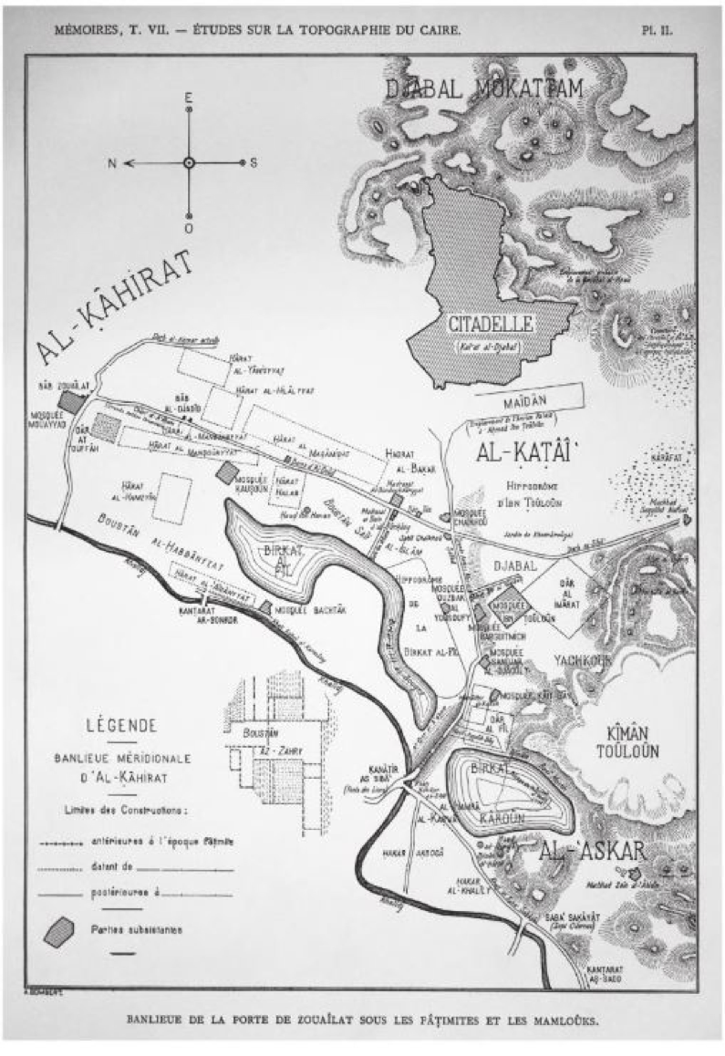
This 1902 Al-Qaṭaʾiʿ map by George Salmon illustrates the Palace/Citadelle, square for military parades, Ibn Ṭūlūn Mosque, and Dār al-ʿImāra. Tariq Salim argues that the map shows al-Qaṭaʾiʿ as it appeared in the Mamluk period, which creates some confusion in studying al-Qaṭaʾiʿ. Source: Swelim 2015.
Ibn Ṭūlūn’s son Abu al-Jaish Khumārūiyah succeeded his reign. Khumārūiyah was particularly fond of luxury, thus he expanded the palace and added a Mesopotamian-style artificial garden, a pond, and a great hall that was called “the House of Gold.” The palace became a legend admired by poets and historians. The Tulunid period lasted for nearly 40 years, and when it ended in 905 AD, the Abbasids returned to rule Egypt. In turn, they destroyed al-Qaṭaʾiʿ to vindicate Ibn Ṭūlūn and his descendants’ attempts at independence. The only structure that survived from that period was the Ibn Ṭūlūn Mosque (Raymond 2007). The ruling center became a military headquarters in part of al-Fusṭāṭ. Al-Fusṭāṭ became a major commercial city of strategic importance. The capital city expanded and eventually incorporated al-ʿAskar in its borders, and remained the capital of Egypt until the arrival of the Fatimids.
The Shia Fatimid caliphate was established in North Africa, in Tunisia circa 909-910 AD. The caliphate invaded Egypt in 969 AD and Al-Muʿiz al-Fāṭimy became Egypt’s ruler and established Cairo in 974 AD as the capital of the Fatimid caliphate (Abu-Lughod 1971). During the eleventh century AD, there were two cities: the first is Miṣr/al-Fusṭāṭ, which was a center for trade and industry; the second was al-Qāhira (Cairo), the new Fatimid city that was designed to meet the needs of a diverse and complex society. Al-Qaṭaʾiʿ continued to deteriorate for two centuries after its destruction in 905 AD. The remaining parts of Al-Qaṭaʾiʿ were used to extract building materials, create new living quarters for marginalized peoples, and create “al-Qarāfah,” or cemeteries, where the land was in ruins (today, this area is called largely “The City of the Dead” by foreigners). The cemeteries expanded among the ruins in the West and toward Mount al-Muqaṭṭam. In the East they started from “al-Qarāfah gate,” located between Ibn Tūlūn Mosque and Salāḥ al-Dīn’s castle, and extended almost a mile. Al-Qarāfah was a burial site for political and religious dignitaries of the Abbasids and those who came after them, including al-’Imām al-Shāfi`ī and al-Sayyida Nafīssa whose tombs were turned into shrines and have been a destination for pilgrims (Abu-Lughod, 1971).
By the end of the eleventh century until the middle of the twelfth century, Cairo had become stronger than any other city and attracted the political administration and the elite from al-Fusṭāṭ. Beginning in the eleventh century, a series of disasters struck al-Fusṭāṭ: the great plague in 1063, an earthquake in 1138, and the razing of the city during the Crusades in 1168, completely destroying civilian life in the city. These events pushed the residents, political administration and the elite of al-Fusṭāṭ to migrate to Cairo and the temporary camps surrounding the city (Abu-Lughod 1971).[1] Although the city was still the capital of the Shia Fatimid caliphate, the ruler at that time was a Sunni minister, Ṣalāḥ al-Dīn, who later defeated the Crusades in battle.
At first, Ṣalāḥ al-Dīn ruled as the governor of Egypt from Cairo and did not express plans to enact major change in the city. Al-Dīn, however, quickly demonstrated his desire for independence and launched several military campaigns (1174-1175). Within one year, he reigned control of Egypt as well as Syria, the territory of Nūba in North Africa, the Western Arabian Peninsula, and Palestine. After these occupations, Ṣalāḥ al-Dīn started plans to build a fort to protect the city, and a wall to bring Cairo and Miṣr/al-Fusṭāṭ together. The castle served as a fortress and residence for the army as well as the personal residence and headquarters of Ṣalāḥ al-Dīn. The construction of the castle was on the verge of completion, but stopped upon Ṣalāḥ al-Dīn’s death in 1193; the construction of the wall continued for 45 years. During the reigns of his successors, residents began to build around the big streets and squares. Schools and mosques replaced the great palaces, while small palaces were converted into commercial buildings as economic life flourished after integrating Miṣr/ al-Fusṭāṭ into Cairo (Abu-Lughod 1971).
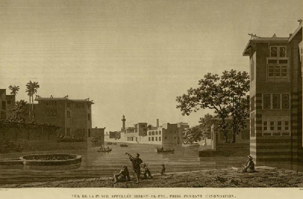
A view of Birkit al-Fīl and the houses surrounding it. Photographed by a French Orientalist after nearly 800 years of demolition of al-Qaṭaʾiʿ. Source: Commission of Scientists and Arts in Egypt 1809.
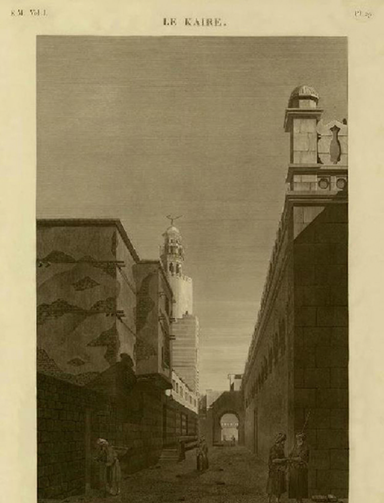
Exterior view of the Ibn Ṭūlūn Mosque. Photographed by a French Orientalist after nearly 800 years of demolition of al-Qaṭaʾiʿ. Source: Description de l’Égypte, 1809.
The al-Khalīfa neighborhood remained home to the largest and oldest historical cemeteries in Cairo, while residential areas extended from the castle to Ibn Ṭūlūn Mosque. When Sultan al-Nāṣir Bin Qalā’ūn came to power, the walls of the old city were restricting the expansion and development of the city. Qalā’ūn subsequently opened new land behind the walls for development and housing, and the land beyond Ibn Ṭūlūn Mosque and parts of the great al-Khalīfa cemetery became popular areas for housing. It is likely that the urban fabric that was developed at the time is the same fabric that still exists in al-Khalīfa today. From the thirteenth to the fifteenth century, Cairo expanded five times the size of its first urban core, located inside the wall (Abu-Lughod 1971).
Al-Khalīfa was not an economic or political center, but it was distinguished by the mosques, shrines, and tombs, many of which were built during the Fatimid era. The Fatimids sanctified the Prophet, his relatives, and descendants (āhl al-Bayt), thus they were eager to frequent the shrines. Egyptians, most of whom are Sunni, have become increasingly prone to frequenting shrines (due to the popularity of Sufi orders and practices in Egypt). In subsequent Sunni periods, rulers renovated and built shrines, making them an integral part of Egypt’s religious culture. Pilgrims continued to visit the shrines from all over Egypt to hold special religious celebrations (mūlid, muwālid pl.) on scheduled dates over the course of days where they gathered with many others, camping out on the streets and parks, decorating the neighborhood, and practicing devotional rituals. The culture stemming from this era and these celebrations are still present and play a role in life in this neighborhood. Here lies the importance of the al-Khalīfa neighborhood and the story that each generation passes on.
The place and its inhabitants
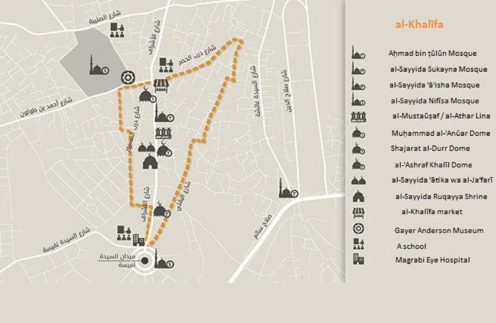
Main landmarks in the al-Khalīfa neighborhood. Source: Tadamun 2016
The main route in the neighborhood is known by residents as al-Khalīfa al-ʿUmūmy Street. Part of the street was renamed recently to al-Ashrāf Street (the honorable descendants of the prophet), as it contains shrines to the Prophet’s descendants. The street begins at al-Sayyida Nafisa Square and meets three other streets: Ṭūlūn, al-Raqayba, and Darb al-Ḥuṣar, forming a small public square containing the al-Khalīfa market.
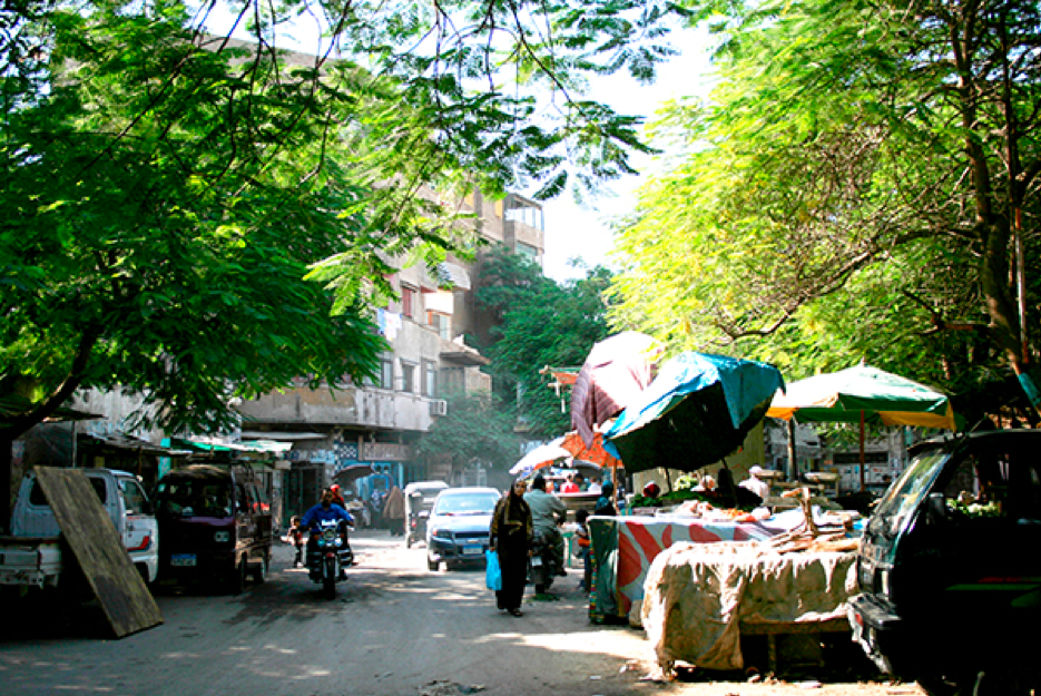
When TADAMUN staff asked residents to map and make a drawing of their area, they suggested the market was as important as al-Sayyida Nafisa Square and Ibn Tūlūn Square. Local inhabitants see this market as the center of commercial services, where vendors display their goods on mats and carts, and there are also a few small shops on each side of the street. Vendors sell daily necessities including food, drinks, household utensils, detergents, and other items. There are low, adjoining houses along both sides of the street, as well as alleyways branching out between houses. Along the street are food shops, coffee shops, bakeries, and small grocery shops, in addition to carpentry workshops, furniture, and other wood crafts in general, and handicrafts such as leather, shell, and metal products.
Al-Sayyida Nafisa Square. Source: Tadamun 2016
Al-Khalīfa Market. Source: Tadamun 2016
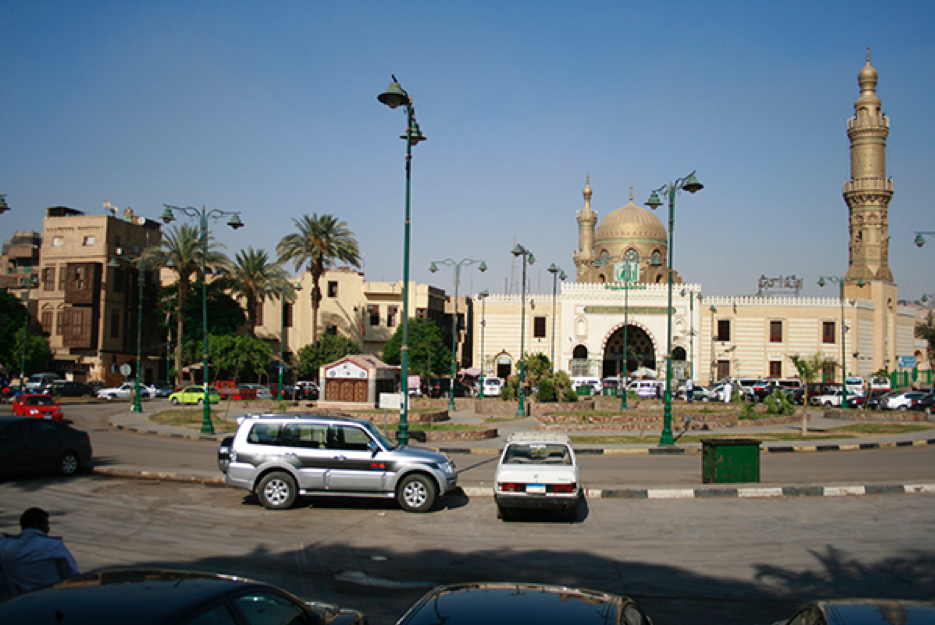
Ibn Ṭūlūn Square and al-Sayyida Nafīsa Square are the two most important points of congregation in the region. Ibn Ṭūlūn Square connects the neighborhood, through Būr Saʿīd Street, to al-Sayyida Zaynab Square, another important square in Cairo. Ibn Ṭūlūn Square itself is an important tourist attraction as it includes both the Ibn Ṭūlūn Mosque and the Gayer Anderson Museum (Bayt al-Krītlīyya). The Gayer Anderson Museum has an unusual history because while the building dates to 1631 AD and is one of the finest examples of 17th century residential architecture in Egypt, it was Major R.G. Gayer-Anderson Pasha, a self-styled Orientalist who lived in the house between 1935 and 1942 with special permission from the Egyptian Government, and filled it with period furnishings, décor, and his extensive antiques collection from his decades of living in Egypt.
Al-Sayyida Nafīsa Square is located at the southern entrance of the al-Khalīfa area, and connected to Ṣalāḥ Sālim Road and al-Sayyida ʿĀʾisha Square. The square is surrounded by prominent buildings including al-Maghrabī Eye Hospital and the historical al-Sayyida Nafīsa Shrine. The shrine is the second station in “Ahl al-Bayt Trail,” a famous path that starts with the Zain al-ʿĀbidīn Shrine and then proceeds to the al-Sayyida Nafīsa Shrine, al-Sayyida Sukayna Shrine, al-Sayyida Ruqayya Shrine, Sīdī Muḥammad bin Jaʿfar al-Ṣādiq Shrine, and al-Sayyida ʿĀtika Shrine.
An annual mūlid, lasting six days is held in Al-Sayyida Nafīsa Square, one of the most significant saints festivals in Egypt. During the ritual, the square is decorated with colorful lights, street vendors bring and decorate their carts for a procession, visitors pitch tents, and dervishes and singers perform their celebratory dances and songs.
Rituals of visiting venerated religious figures, where people sit on mats around the shrines in an expression of propitiation. Source: Athar Lina Initiative. n.d.
To understand the socio-economic conditions of Historic Cairo, Sherine Zaghow compared Historic Cairo to the rest of Cairo in a 2011 UNESCO study. The study revealed that Historic Cairo suffers from some of the worst conditions in the city and contains some of the most deteriorated areas. While the average population density is 29.8 individuals per hectare in the city of Cairo, areas in Historic Cairo have densities between 66 individuals to 574 individuals per hectare. In al-Khalīfa (the shiyakha), the population density is 429.1 individuals per hectare. The average rate of illiteracy in Cairo is 15 percent, while it reaches 26 percent in al-Khalīfa, an increase from twenty years ago. Yet at the same time, according to the Zaghow, Historic Cairo has witnessed a remarkable improvement in living conditions since the 1980s. While literacy rates increased, the unemployment rate went down—from 20.1 percent in 1986 to 9.4 percent twenty years later, in 2006. Comparing areas, unemployment rates in Historic Cairo ranged from three to eight percent in 2006, with al-Khalīfa at four percent. Zaghow attributed this improvement to many changes related to the growth of business and commerce in the areas of Historic Cairo and the spread of street vendors (2011).
The population density in al-Khalīfa may seem lower than in some other parts of Historic Cairo, however, a very large area of the neighborhood is occupied by the southern cemeteries of Cairo. In general, the majority of the neighborhood’s residents were born there, where they inherited their homes from their parents and grandparents, and al-Khalīfa is the only home they know. As for newcomers, their numbers vary from one shiyakha to the other. Most homes are owned by their inhabitants, but there are rental homes as well.
Newly constructed buildings reach up to eight floors, despite the narrow streets. Source: Athar Lina Initiative. n.d.
A photo of al-Khalīfa Street, taken from the top of al-Sayyida Sukayna Mosque’s minaret. It shows the al-Sayyida Ruqayya Dome, the Shajarat al-Durr Dome and the adjacent al-Khalīfa service center (al-Mustaūṣaf), among residential buildings. Source: Athar Lina Initiative. n.d.
There are a variety of economic activities in al-Khalīfa neighborhood, where the unemployment rate is relatively low. Residents work in both the public sector and the private sector, in both governmental and working-class jobs (especially in the furniture and woodworking industries). Al-Khalīfa is not an especially important commercial hub, but it has the goods and stores needed to serve the local population and is connected to big commercial markets in surrounding areas, markets that serve all of Cairo and in which many residents of al-Khalīfa work.
Characteristics, problems, and needs of the al-Khalīfa neighborhood
The Tadamun Initiative organized a community meeting for al-Khalīfa residents and the participants discussed the desirable characteristics of the neighborhood. One of its most important characteristics is its central location in Cairo, or as one participant explained, “al-Khalīfa is the navel of Cairo” (Tadamun 2016).
The neighborhood provides its residents with a sense of social solidarity, strong connections between families, and security. Residents depend on the generations-long neighborly relations to fulfill their needs, support each other, and solve problems and conflicts. Other advantages include the availability of grocery stores and other daily needs in the local market which is located within walking distance from homes. Public services are available to a reasonable degree, with schools and hospitals in surrounding areas serving the neighborhood. Despite this progress, there are still drawbacks to living in al-Khalīfa. The al-Khalīfa hospital has been closed for years, forcing residents to crowd nearby facilities. Mothers have few daycare options, limiting their ability to engage in paid work. Transportation within the area itself remains difficult since the streets are narrow and traffic jams have increased, while transportation options (public and private) are fewer. There is a lack of cultural, sport, and social services targeted towards young people.
Like the rest of Cairo’s historic areas, many of its old buildings have collapsed or are in danger of collapsing. Many of the infrastructure problems are because the sewage and water networks are old, worn out, and insufficiently maintained. This affects the quality of drinking water in the area and thus the health of its population. Homes are also old, making it technically difficult to connect them to the natural gas network, which negatively affects the level of well-being and comfort of the population.
Al-Husayneyya Lane (ḥāra) in al-Khalīfa neighborhood. The photo shows examples of deteriorated old buildings. Source: Athar Lina Initiative. n.d.
With the exception of roads in the main square, dirt roads lack cleaning and lighting services, including al-Khalīfa al-`Umūmy Street/al-’Ashrāf Street. Officials declared that the “problems in the neighborhood are related mainly to overseeing and securing old buildings and their inhabitants, through frequent checks and implementing decisions issued thereon” (Cairo Governorate 2019). The situation requires a comprehensive intervention strategy rather than dealing with each building separately. There is a real need to begin restoration and maintenance work for the area’s buildings as part of a larger development plan and in partnership with the population.
Residents underlined the area’s need for an efficient garbage collection system. At present, vehicles belonging to a private company collect garbage twice a week from houses and from designated areas on the main streets. The garbage collectors demand that the residents pay a monthly amount, although neighborhood officials have told the residents that the authorities in the neighborhood have contracted the company and they are the ones who are paying for it, not the residents. Yet, if the residents do not pay, the garbage service will ignore them. Additionally, the garbage trucks only come infrequently, forcing residents to throw garbage in the street, thus polluting the street, endangering the environment, and public health.
Due to the difficulty of installing natural gas connections into old houses, residents are encumbered by having to rely on gas cylinders (butagas). Some residents are aware that their homes are not eligible for these updates because their houses do not meet the required technical standards. However, many residents reject this technical difficulty, arguing that the buildings of al-Hilmiyya are similar to those in al-Khalīfa, and yet al-Hilmiyya is now connected to the natural gas network.
Residents, especially women and children, pointed to the lack of green areas and places for social and recreational activities open to families and children to play and learn, such as clubs, youth centers, and parks. Girls and women have expressed discontent with the proliferation of coffee shops in the area (that only serve men). They said that these coffee shops occupy large areas of the street and they find it difficult to move between their homes, workplaces, or school. Girls are sometimes harassed by the men who frequent them and many complain about the loud music blasted from these coffee shops until the early hours of the morning.
Finally, a great deal of discussion took place regarding the issue of heritage and the local population’s relationship to it. The residents considered the existence of historical mosques is one of the most important features of the area, as it increases tourism if these sites were managed appropriately. Famous mosques and shrines are visited by many people to worship and participate in rituals. And when entertainment activities occur in the streets around them, local people get entertained as well. People pointed out a party organized by the governorate, which included singers, musicians, and games, that local people of all ages were happy to be part of it. Participants at the community meeting expressed their hope to have development and renovation work on homes and monuments similar to the initiatives implemented in al-Gammāliyya and al-Darb al-’Aḥmar areas. These interventions made these two areas comfortable for residents and popular with visitors, which encouraged more tourism and commerce that opened up many opportunities for work and economic gain.
In addition to development projects in the al-Gamāliyya and al-Darb al-’Aḥmar areas, residents of al-Khalīfa mentioned that the Masākin Zaīnhum project had a massive influence on their life. The site of this project used to be known as `Ishash (shacks) Zaīnhum, adjacent to al-Khalīfa. Residents of both areas frequented a market that was between them and worked in similar jobs. After `Ishash Zaīnhum was demolished to construct the Masākin Zaīnhum public sector housing project, which had been planned since the late 1990s, the new buildings were now entirely separate from al-Khalīfa since they were built on the top of a hill. This caused the demolition of the common market, and decreased interactions between the residents and caused some shops in al-Khalīfa to close as they lost their costumers from `Ishash Zaīnhum. The new project included the provision of public services, but these services did not extend to the preexisting surrounding areas. Wastewater and drinking water began to leak from the high elevation in Zaīnhum down to al-Khalīfa, causing structural damage to historic buildings such as the al-’Ashraf Khalīl and the Fāṭima Khātūn domes, as well as to residential buildings (Athar Lina Initiative, personal interview, 2016.) Development projects should not conceptualize the city as disconnected, separate sections; projects must take into account the relationships between areas and assess the impact of the development of one area on the surrounding areas. Despite the fact that the development projects in Zaīnhum, al-Gamāliyya, and al-Darb al-’Aḥmar are among the most successful projects in Cairo, it is incumbent upon the authorities and their local agencies to manage resources well and ensure equity between regions, especially adjacent areas.
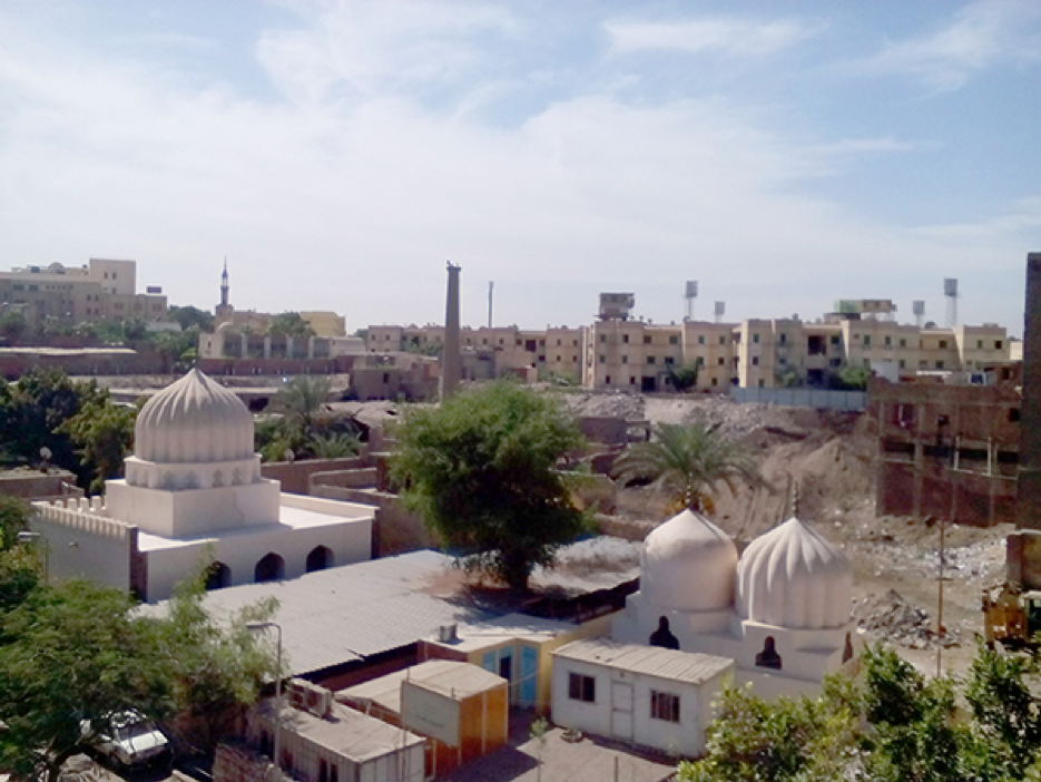
The site of al-’Ashraf Khalīl Shrine (the dome on the right) and Fāṭima Khātūn shrine (the middle). Source: Athar Lina Initiative. n.d.
The Athar Lina initiative: The complicated issue of antiquities ownership
The Athar Lina [Heritage is Ours] Initiative as its name suggests, calls for restoring ownership of antiquities and monuments to the community, which can then become a resource for community development. According to the declared objectives of the initiative, “the community becomes an effective element in preserving antiquities when these antiquities are a source that benefits it.” The initiative believes that the decision-making mechanism to preserve antiquities must be a participatory process that involves the local community.
The Built Environment Collective launched the initiative in 2012. The organization questions the relationship between heritage sites and communities surrounding them. The initiative focused on the al-Khalīfa area to organize a series of participatory workshops in the hopes of discovering the dimensions of this relationship. They invited the local community and a group of architects and urbanists to work together to develop recommendations for development. One of the most important recommendations was to link the abstract concept of heritage conservation to economic and social benefits for the local community.
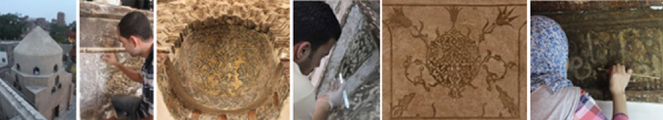
Renovation work done by a team from Athar Lina Initiative in the al-Khalīfa area. Source: Athar Lina Initiative. n.d.
The large dome in al-Sayyida Ruqayya Shrine, and the two smaller domes in al-Sayyida `Atika wa al-Ja`fary shrine, after renovation. Source: Athar Lina Initiative. n.d.
The line of thinking that this initiative promoted has never been dominant in Egypt. Rather, the Egyptian government views local residents that live around monuments as almost hazardous to the monuments. The government treats these communities as an obstacle to address and a problem to isolate, not as an asset to utilize in preserving monuments. For example, a development project for the urban environment around a historical site inside the Al-Khalīfa neighborhood involved the renewal of the path that links al-Rifā`ī Mosque and al-Sulṭān Hasan Mosque with the surrounding yards. The dominant logic in the project was to separate the monuments from the surrounding residents, preventing them from walking around the monuments or entering them (Elsheshtawy 2006). In recent decades, the government had constructed a high wall around the two mosques and restricted access to them by installing gates and security guards who are authorized to prevent people from entering. In an interview conducted in the 1990s with a general manager in the Supreme Council of Antiquities, he defended these measures by arguing that the residents in the surrounding areas of the monuments are lower class, they disturb tourists, and harm Egypt’s image (Elsheshtawy 2006). We believe that the situation has changed to a certain extent, and that the project planners could not execute the measures they had envisioned at the time. It is impossible to prevent the community from visiting the shrines and praying in them, since the people themselves are an important part of the vitality of these shrines and their meaning.
Similar measures were also imposed in al-Rifā`ī Mosque and al-Sulṭān Hasan Mosque in the area surrounding ‘Ibn Ṭūlūn Mosque. Consequently, during the participatory meetings, Athar Lina examined the impact of these policies on al-Khalīfa. Local residents complained that they were cut off from the mosque and that a courtyard where their children used to play soccer had been walled in and appended to the mosque. In addition to that, when the site was developed, residents were no longer able to visit a public garden, and accessing the mosque by the community became harder than ever before. This notion of isolation and exclusion was reinforced when the Gayer Anderson Museum’s management installed iron gates at the entrance and the exit of Ibn Tūlūn Mosque. This was a major inconvenience to residents who were constantly harassed by gatekeepers. During the revolution of January 25th, some individuals tore down the iron fence and sold it as scrap metal. Remnants of the fence are still visible around al-Sayyida Sukayna Mosque (Athar Lina Initiative 2016).
The fence around ‘Ibn Ṭūlūn Mosque. Source: Tadamun 2016
The Athar Lina Initiative has renovated several historic buildings in the area surrounding the Shagarat al-Dor Dome in al-Khalīfa/al-’Ashrāf Street. In line with the principles of the initiative, it involved the host community in its efforts so that they would benefit from the renovations. The initiative also cooperated with relevant governmental agencies, especially the Ministry of State for Antiquities and the Cairo Governorate. According to Athar Lina’s website, the initiative converted the adjacent building into a cultural community center, in addition to renovating three domes built in the thirteenth century. The restoration activities were not separate from its mission to raise awareness of the history of these monuments and help the community, especially children and young people, forge connections with these landmarks. The initiative held participatory workshops, symposia, and exhibitions that targeted representatives of the community and the Heritage School, which serves the community’s children in the summer and helps them connect to their local historical and cultural milieu. The initiative also focused on collecting oral histories and stories from local people and bringing them back into public awareness, emphasizing the community’s celebration of their tangible and intangible heritage alike. As an annual activity to promote tourism, the initiative organizes walking tours under the name, “Spend Your Day in al-Khalīfa.” In addition to conveying the historical information about the buildings, the tour guides explain local myths about the area’s heritage to visitors from stories passed down through generations that live on through al-Khalīfa’s collective memory. The initiative transformed these stories into a theatrical play, bearing a title that attests to its content: “Al-Khalīfa from the Inside Out.”
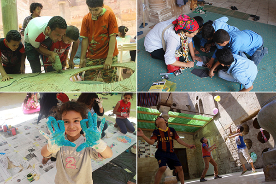
The children of al-Khalīfa found a sanctuary to express their creative energies, play and learn in Mustaūṣf al-Khalīfa building in the headquarters of the Athar Lina Initiative and Megawra. Source: Athar Lina Initiative. n.d.
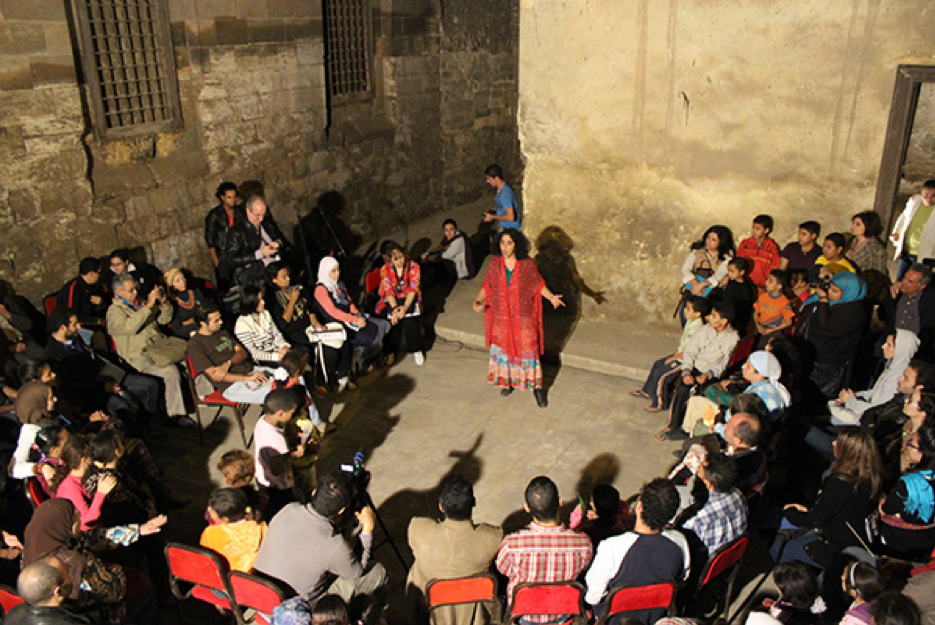
A theatrical play, titled “Al-Khalīfa from the Inside Out.” It was attended by the local community and people from all over Cairo. Source: Athar Lina Initiative. n.d.
Legends of al-Khalīfa: documenting and recording oral history
History is a series of stories, some of which receive attention, support, and documentation in reliable sources, and some of which travel through generations, and mix with legends. Athar Lina documents both kinds of history to reveal what people value through storytelling, what they leave behind, and how history shapes communities.
The inhabitants of al-Khalīfa have tales about most of the monuments in their region, from the oldest medieval monuments to the houses of the last century. There are more legends and imaginary stories that surround the Gayer Anderson Museum/Bayt al-Kritliyya than any other historical site in the area. For example, many people believe that the well in the lobby is enchanted and upon looking inside, you will see your future lover. It is said that the well has catacombs where the king of the bats lives and guards a great treasure, and that many people descended into the well in search of the treasure and died there. It is also said that the ‘bat king’ is a good and generous king and that he gives those in need a gold coin when they dangle a bucket in the well. Many believe that the spirit of al-Shaīkh Hārūn, whose tomb is close to the building entrance, guards the building and protects it from thieves– rather than the building’s iron gate and security guards. Another story relates to the namesake of the museum, Gayer Anderson, who was a British officer stationed in Egypt during World War I (and later worked for the Egyptian colonial government). It is said that a girl looked at him from a window and invited him to enter the house. He fell in love with the house, later living in it at the invitation of the Egyptian government, converting it to a museum for his antiques which he had collected during his long residence in Egypt. The museum is still operating to this day.
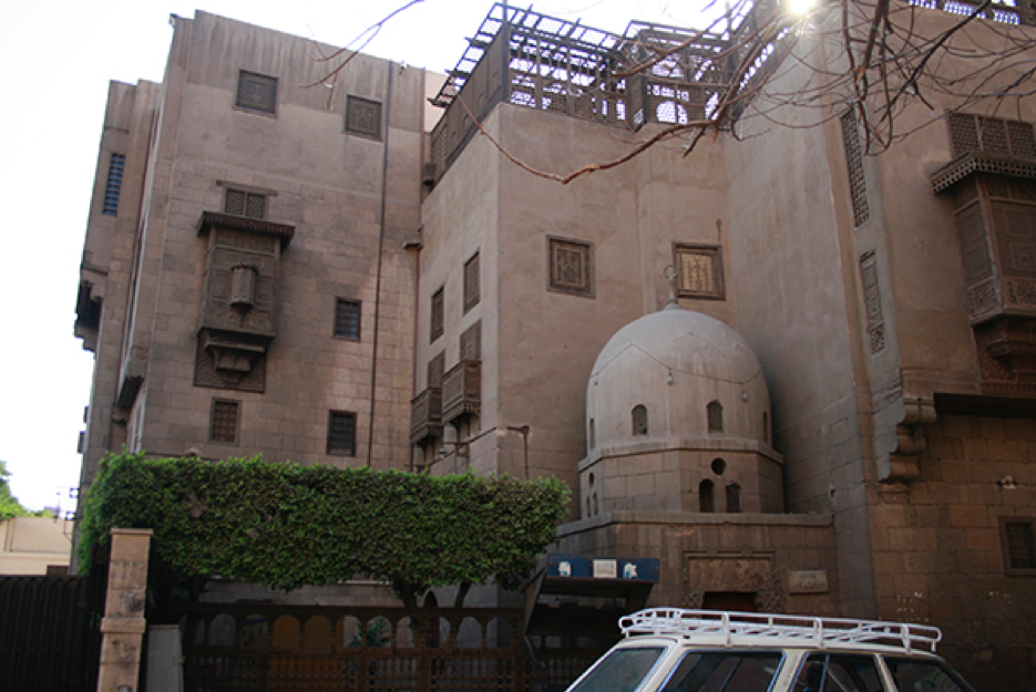
Gayer Anderson Museum. Source: Tadamun 2016
Some people believe that ‘Ibn Ṭūlūn Mosque is cursed because it was built in the likeness of al-Ka‘ba in Mecca; al-Sayyida Zaynab allegedly pointed to it and said: “This will be ruins, oh Ibn Tūlūn.” There is another more popular legend that says that Mount Yashkur, where the mosque is located, is the place where Noah’s Ark docked. Other people believe that Ibn Ṭūlūn found a treasure and used the money to build the mosque, which shows his integrity since he did not keep the treasure for himself. Birkit al-Fīl (The Elephant’s Pond), which is located in the al-Sayyida Zaynab neighborhood nearby, may have received its name from elephants that Ibn Ṭūlūn allegedly used in the construction of the mosque.
The team of Athar Lina relayed some of the stories that demonstrate the sanctity of the shrines for religious practitioners. During their renovations of three shrines, the team met many of the people who came regularly to visit and pray at the shrines. One time they met a physician who came twice to clean the tomb of al-Ja`fary and to remove the water that seeped in to it. She said that she saw al-Ja`fary in her dreams and his beautiful face was tarnished with mud. The team told her that al-Ja`fary was not actually buried there, and she walked away angry at them. On another occasion, a woman came and said that she wanted to convey a message to the team from al-Sayyida Ruqayya who came to her in her dreams. She said that the team should expand the shrine. When the Athar Lina team told her that it is important to preserve the old structure, she said that if they did not do what she asked for, a column would fall on their heads which would have killed them. The team was engaged in a dangerous process of changing the shrine’s columns at the time, so they were disturbed by this ominous prophecy.
Al-Khalīfa residents are fond of stories. In addition to historical legends, there are stories about resisting the British army in the streets of al-Khalīfa. Another story describes a beautiful house in Darb al-Habbāla, which is believed to have belonged to Siyyd Bik Taha who is one of the heroes of al-Fallūja battle in Palestine in 1948. And there is another story about a house that belonged to woman who was called Sākna and was a singer and a dancer. It is said that Khedive ’Isma`īl was one of her fans and addressed her as “Sākna Hānim” (lady). When the ladies of the royal family objected that the ruler of the country was addressing a dancer as a lady, the Khedive bestowed upon her the rank of Pasha to spite the ladies of the royal family.
The importance of compiling, documenting, and presenting stories is to preserve collective memory, history and to understand the community’s relationship to place. The legends that people tell about place are a history that forms their consciousness and reflects it at the same time. The narration of these legends is an important aspect of understanding how they conceive of, and value this place, which certainly transcends the facts and events associated with it, particularly those that have disappeared from history books.

Top right: a team from Athar Lina Initiative drawing a mural to highlight the most important tourist attractions in al-Khalīfa. Top left: a mural by Athar Lina presenting the most important landmarks at the entrance of al-Khalīfa Street. Below: al-Khalīfa tours. Source: Athar Lina Initiative. n.d.
The urban revival of historic Cairo: Heritage as a platform for community development
As mentioned at the beginning of this chapter, al-Khalīfa is located within Historic Cairo, which was added to UNESCO’s World Heritage List in 1979 under the name “Islamic Cairo.” The UNESCO World Heritage Committee proclaimed that the value of Cairo goes beyond its role as a historic capital of the Islamic world, as it represents one of the marvels of urban human experience throughout human history (UNESCO World Heritage Center 2014). This inclusion on the World Heritage List means that the area has outstanding international value, and should be preserved under the supervision of the World Heritage Committee in accordance with the Convention for the Protection of the World Cultural and Natural Heritage. The Guidelines for the Implementation of the World Heritage Convention explains that “Outstanding Universal Value means cultural and/or natural significance which is so exceptional as to transcend national boundaries and to be of common importance for present and future generations of all humanity. As such, the permanent protection of this heritage is of the highest importance to the international community as a whole” (Article 49). The continued inclusion of the site on UNESCO’s list depends on preserving the characteristics that have met the criteria for World Heritage and made the site eligible for inclusion on the list (UNESCO World Heritage Center 2019). There are three such characteristics in Islamic Cairo. First, many great monuments in Cairo are undoubtedly magnificent archaeological artifacts. Second, the center of Cairo contains many old streets and homes, preserving the traditional urban fabric that dates back to the Middle Ages. Third, Islamic Cairo bears witness to the political, strategic, cultural and commercial activities of the city during the Middle Ages, and serves as a reminder of the city’s international importance (International Council of Monuments and Sites 1979).
In 2009, the World Heritage Committee launched the Urban Regeneration Project for Historic Cairo (URHC) thirty years after its inclusion on the World Heritage List. The project aims to address the absence of standards for the protection of the architectural and urban value of the area, as well as to define clear boundaries for it. It also aims to develop operational tools for urban conservation and management via a special fund for Egyptian cultural heritage through UNESCO (URHC 2019). The project began in 2010 with the cooperation of Egyptian authorities and the participation of a number of Egyptian and foreign researchers and consultants in order to: produce a wide range of studies, develop a common vision for the future of architectural heritage and the historical urban fabric, and develop a strategy to protect and rehabilitate the region in a manner that combines spatial and functional considerations with cultural, social, and economic considerations. The project is based on the concept that the conservation of material heritage requires sustainability. The project is in its early stages, and work is underway to prepare a management plan and to identify appropriate tools for urban conservation as well as for the fiscal management of the historical region (URHC 2013).
A map of Historical Cairo. It includes the al-Khalīfa area under the name “the location of the Tulunid city, al-Qaṭa’i`. Source: Urban Regeneration Project for Historic Cairo 2019
The Egyptian government remains the decision-maker and the main player in conservation efforts. The fact that the area is within the scope of a World Heritage Site may help—or not—in getting support from international institutions by exchanging global expertise in the management and best use of urban heritage as well as through funding. However, the local administration has a permanent responsibility for the management and rehabilitation of this urban area and must pay attention to the needs and problems of the local population. The advantage of al-Khalīfa and other historical areas of Cairo is that studies and projects centered in these areas have provided a great deal of information, knowledge, and tools, along with information on best practices that officials, initiatives, and planners have applied in Cairo’s other historic areas. This will help the Egyptian government make appropriate decisions if and when there is political will to intervene, allowing them to solve problems and improve the social and economic life of the people of the area. Furthermore, the experience of the Athar Lina Initiative has provided knowledge about the appropriate tools for the al-Khalīfa area. It has also provided a living example for coupling development efforts with renovation and conservation efforts. The initiative consistently keeps the goal of serving the community at the forefront of its efforts, which fosters trust between members of the community, experts, and practitioners. Thus, this method allows for cooperation between parties and a space for sharing their dreams and disappointments, knowing that all have given their utmost to achieve what is possible within the limits of available resources. And most importantly, the relationship between the inhabitants of the area, the monuments, and the legends they have created or inherited can serve to promote the heritage preservation.
The exclusion of the population and their interests from the restoration and preservation of monuments, and from urban development more generally, will achieve nothing but the alienation and the separation of the community from these efforts. In this case, the community will no longer feel any responsibility towards the monuments which will make restoration efforts unsustainable, and the community will not achieve the comfort and convenience it deserves. The main motivation for any intervention in the area should be to realize the social, economic, and cultural sustainability of the community and its urban fabric, as well as to promote its members and help them improve their situation. Preserving and supporting monuments and urban heritage sites can provide opportunities to make a living, improve skills, promote education and culture, and build a more open community to welcome visitors from other areas, or even other countries. Antiquities are a resource and not a burden. If we embrace this perspective, it will have enormously positive effects on all our lives.
References
Abu-Lughod, Janet L. 1971. Cairo: 1001 years of the City Victorious. Princeton, N.J. Princeton University Press. http://hdl.handle.net/2027/heb.02308.0001.001.
Atharlina. 2019. “Al Atharlina Built Environment Collective.” http://www.atharlina.com/.
Cairo Governorate. 2019. http://cairo.gov.eg/ar/Imp%20Information/Pages/default.aspx
Central Agency for Public Mobilization and Statistics. 2006. “The Final Results: General Census of Population and Housing Conditions.” http://www.tseries.capmas.gov.eg/pdf/census/censes/cens_pop2006_01.pdf
Commission of Scientists and Arts in Egypt. 1809. Description de l’Égypte. Vol 7: Modern State I, p. 60, Plate 29, Cairo. French government.
Elsheshtawy, Yasser. 2006. “Urban Transformation: Social Control at al-Rifa’i Mosque and Sultan Hasan Square.” Cairo Cosmopolitan: Politics, Culture, And Urban Space in The New Globalized Middle East. Diane Singerman and Paul Amar, eds., 295-312. Cairo: The American University in Cairo Press.
International Council on Monuments and Sites. 1979. “Nominations on the World Heritage List The Historical Centre of Cairo – Egypt – 089”. PARIS: ICOMOS. http://whc.unesco.org/archive/advisory_body_evaluation/089.pdf
Open Data for Africa. 2015. “Egypt Census, 2006 – Egypt Data Portal.” The African Development Bank. http://egypt.opendataforafrica.org/EGSNS2006/egypt-census-2006.
Raymond, André. 2007. Cairo: City of History. Cairo: The American University in Cairo Press.
Swelim, Tarek. 2015. Ibn Tulun: His Lost City and Great Mosque. Cairo: The American University in Cairo Press.
Tadamun. 2016. “Community Workshop: Al-Khalīfa.” Tadamun: The Cairo Urban Solidarity Initiative. July 13. http://www.tadamun.co/?post_type=voice&p=8177&lang=en#.XZSxSHdFy1s.
Urban Regeneration Project for Historic Cairo. 2019. “Visitor Map.” World Heritage Center. http://www.urhcproject.org/VisitorMap.
Urban Regeneration Project for Historic Cairo. 2013. “Proposed Work Project.” UNESCO Heritage Center. http://www.urhcproject.org/Content/studies/BOOK_Arab_Web_res.pdf.
UNESCO World Heritage Center. 2004. “Convention for the Protection of the World Cultural and Natural Heritage.” http://whc.unesco.org/archive/convention-arb.pdf
UNESCO World Heritage Center. 2005. “Guidelines for the Implementation of the World Heritage Convention.” http://whc.unesco.org/archive/opguide05-arb.pdf
UNESCO World Heritage Centre. 2014. “Urban Regeneration for Historic Cairo.” World Heritage Centre. http://whc.unesco.org/en/activities/663/.
UNESCO World Heritage Center. 2019. “Historic Cairo.” Documents – UNESCO World Heritage Centre. World Heritage Center. http://whc.unesco.org/en/list/089/documents/#ABevaluation.
Zaghow, Sherine. 2011. “Rehabilitation of Historic Cairo: Socio-economic Survey.” UNESCO.
World Heritage Centre. http://www.urhcproject.org/Content/studies/3_zagow_socioeconomic.pdf
Special thanks to the Built Environment Collective – Megawra for its contribution to this brief and research for it.
[1] During the war in 1168, Crusader forces occupied Birkit al-Habash to the south of al-Fusṭāṭ, which raised Shāūir’s concerns (the ruler and a former minister under Salāḥ al-Dīn al-’Ayūbi), that the Crusader forces would make al-Fusṭāṭ a base to launch attacks against the walled Cairo and the castle. He ordered al-Fusṭāṭ burnt to the ground. The fire lasted for 54 days and the inhabitants fled toward Cairo seeking protection.

Comments